
|
|
|
|
|
|
|
|
|
|
|
|
|
|
|
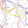
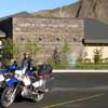
Our longest dual-sport ride of 2004 was very memorable. As shown on the GPS "tracks" map, we made a loop from Clarkston, Washington, through the Magruder Corridor (the Southern Nez Perce Trail) in Idaho to Montana, and back along the Lewis and Clark Trail (the Northern Nez Perce Trail). It was about an 800 mile route that included two major unimproved dirt/gravel/rock roads through some of the truly remote regions of Central Idaho. A good starting place for this ride is at the Lewis & Clark Discovery Center in Lewiston, Idaho, to get an overall perspective of the area and the Lewis and Clark Discovery Corp history.
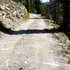
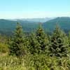
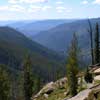
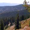
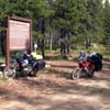
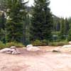
The initial leg of our trip was through the Magruder Corridor, which is a narrow strip of land between two major wilderness areas in Central Idaho. The Magruder road is unpaved and primitive for 101 miles, the longest primitive road in the US. We spent the night at Poet's Creek Campground, bypassing some of the high meadows preceding it, in an attempt to camp at warmer, lower altitudes. That turned out to be a good plan, since after a great dinner and wonderful evening; morning greeted us with sub-freezing temperatures. The Magruder road quickly climbs and switchbacks over and around ridges and saddles, reaching elevations of nearly 8,000 feet, and providing great vistas of the Selway-Bitterroot and Frank Church-River of No Return Wilderness areas.
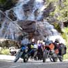
After leaving the primitive road of the Magruder Corridor, we made a big loop around the Southwestern part of the Big Sky country of Montana. Most of this leg was along paved roads except for a well-groomed dirt stretch called Highway 38. A highlight of this section was the Skalkaho Falls.
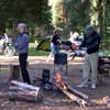
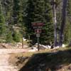
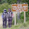
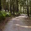
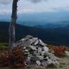
Our route home included the other major primitive road of our journey, the Lolo Motorway. This is a single-lane, dirt/rock winding road that traverses ridges and descends onto saddles as it rather closely follows the Nez Perce National Historic Trail. This is the route used by Lewis and Clark in their western expedition of 1805 and their return to St Louis in 1806. The Motorway, mostly built by the Civilian Conservation Corps in the 1930s, is 73 miles long and somewhat more primitive than the Magruder road of our first leg. When traveling west, the beginning of this historic road is near Powell Junction, just beyond Lolo Pass on Highway 12. Although rough in spots, the route offers great vistas over the Lolo Pass area and nice winding sections through the forests. There are important historic areas marked along the route, like The Smoking Place, where Lewis and Clark smoked the pipe with their Indian companions/guides before resuming their challenging trek through the snow-covered mountains. There is also the Indian Post Office at nearly 7,000 feet elevation, where for centuries, Indians passing these sacred stone piles would leave a personal item that would tell subsequent travelers that they had already passed through here. It was quite an experience to travel through such wilderness and know that this very route was important to two different cultures. Our final treat on the Lolo Motorway was our great camping spot at Rocky Ridge Lake. We had lake-front property with a wonderful view, a nice warm campfire and a good dinner with great friends. What a trip!
HTML by
Thomas R. Powell & Associates
Last updated on 02/20/2012.